A dynamic evaluation of landscape transformations based on land cover data
DOI:
https://doi.org/10.3097/LO.2022.1097Keywords:
Landscape, Land cover and land use, CORINE Land Cover (CLC), Spatial planningAbstract
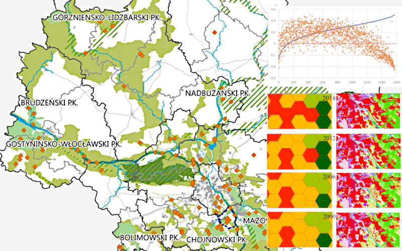
The present era is characterized by unprecedented levels of human activity, which adapt the world to our needs and induce transformations in landscape morphology and physiognomy. The Anthropocene is a remarkable epoch, where changes in space are not only visible, but also confirmed by an extensive body of research. Human activities lead to the creation of numerous tools for measuring the scale of anthropogenic pressure. Satellite and photogrammetric data that broaden our field of vision and change the scale of reference from local to global or even beyond global. These data support observations of the present condition of the surrounding space as well as the rate of changes in space. In the present study, land cover data were used to monitor changes in the surrounding landscape. A system for classifying evolutionary changes in space was proposed to monitor land-use transformations and describe landscape stability. The applicability of CORINE Land Cover (CLC) data for such analyses was evaluated. The research hypotheses and the proposed procedure were tested in the Mazovian (Polish: Mazowieckie) Voivodeship and the city of Warsaw, the Polish capital and the central point of the analyzed voivodeship which generates continuous changes in space. The results of the study confirmed the research hypotheses and demonstrated that CLC data are suitable for monitoring spatial changes.
References
Antrop, M. 2005. Why landscapes of the past are important for the future. Landscape and Urban Planning, 70(1–2). https://doi.org/10.1016/j.landurbplan.2003.10.002
Barros, J. L., Tavares, A. O., Monteiro, M., & Santos, P. P. 2018. Peri-urbanization and rurbanization in Leiria city: The importance of a planning framework. Sustainability (Switzerland), 10(7). https://doi.org/10.3390/su10072501
Barthel, S., Isendahl, C., Vis, B. N., Drescher, A., Evans, D. L., van Timmeren, A. 2019. Global urbanization and food production in direct competition for land: Leverage places to mitigate impacts on SDG2 and on the Earth System. Anthropocene Review, 6(1–2). https://doi.org/10.1177/2053019619856672
Batty, M. 2010. Space, scale, and scaling in entropy maximizing. Geographical Analysis, 42(4). https://doi.org/10.1111/j.1538-4632.2010.00800.xBiłozor, A., Cieślak, I., Czyza, S. 2020. An analysis of urbanisation dynamics with the use of the fuzzy set theory-A case study of the city of Olsztyn. Remote Sensing, 12(11). https://doi.org/10.3390/rs12111784
Biłozor, A., Czyża, S., Bajerowski, T. 2019. Identification and Location of a Transitional Zone between an Urban and a Rural Area Using Fuzzy Set Theory, CLC, and HRL Data. Sustainability, 11(24), 7014. https://doi.org/10.3390/su11247014
Bogaert, J., Vranken, I., André, M. 2014. Anthropogenic Effects in Landscapes: Historical Context and Spatial Pattern. In Biocultural Landscapes. https://doi.org/10.1007/978-94-017-8941-7_8
Brown, A. G., Tooth, S., Chiverrell, R. C., Rose, J., Thomas, D. S. G., Wainwright, J., Bullard, J. E., Thorndycraft, V. R., Aalto, R., Downs, P. 2013. The Anthropocene: Is there a geomorphological case? In Earth Surface Processes and Landforms (Vol. 38, Issue 4). https://doi.org/10.1002/esp.3368
Chen, J., Liu, Y. 2014. Coupled natural and human systems: a landscape ecology perspective. In Landscape Ecology (Vol. 29, Issue 10). https://doi.org/10.1007/s10980-014-0125-9
Cieślak, I. 2019. Identification of areas exposed to land use conflict with the use of multiple-criteria decision-making methods. Land Use Policy, 89. https://doi.org/10.1016/j.landusepol.2019.104225
Cieslak, I., Szuniewicz, K., Czyza, S. 2016. Analysis of the Variation of the Areas under Urbanization Pressure Using Entropy Index. Procedia Engineering, 161. https://doi.org/10.1016/j.proeng.2016.08.793
Cieślak, I.; Szuniewicz, K.; Pawlewicz, K.; Czyża, S. 2017. Land Use Changes Monitoring with CORINE Land Cover Data. In IOP Conference Series: Materials Science and Engineering; IOP Publishing: Bristol, UK, Volume 245, p. 052049. doi:10.1088/1757-899X/245/5/052049
Cieślak, I., Biłozor, A., Szuniewicz, K. 2020. The use of the CORINE Land Cover (CLC) database for analyzing urban sprawl. Remote Sensing, 12(2). https://doi.org/10.3390/rs12020282
Collins, C. D., Holt, R. D., Foster, B. L. 2009. Patch size effects on plant species decline in an experimentally fragmented landscape. Ecology, 90(9). https://doi.org/10.1890/08-1405.1
CORINE Land Cover. (n.d.). 2018. Retrieved June 20, 2019, from clc.gios.gov.pl
Crutzen, P., Schwägerl, C. 2011. Living in the Anthropocene: Toward a new global ethos. Yale Environment.
Czyz, T., Hauke, J. 2015. Entropy in Regional Analysis. Quaestiones Geographicae, 34(4). https://doi.org/10.1515/quageo-2015-0037
Demir, S. 2019. Landscape dynamics changes of the protected Mary valley, Turkey. Applied Ecology and Environmental Research, 17(2). https://doi.org/10.15666/aeer/1702_35913613
Drusa, M; Yilmaz, I; Marschalko, M; Coisson, E; Segalini, A. 2016. Analysis of the variation of the areas under urbanization pressure using entropy index. In World multidisciplinary civil engineering-architecture-urban planning symposium- WMCAUS 2016
Ellis, E. C., Wang, H., Xiao, H. S., Peng, K., Liu, X. P., Li, S. C., Ouyang, H., Cheng, X., Yang, L. Z. 2006. Measuring long-term ecological changes in densely populated landscapes using current and historical high resolution imagery. Remote Sensing of Environment, 100(4). https://doi.org/10.1016/j.rse.2005.11.002
Espinosa, M. O., Polop, F., Rotela, C. H., Abril, M., Scavuzzo, C. M. 2016. Spatial pattern evolution of Aedes aegypti breeding sites in an Argentinean city without a dengue vector control programme. Geospatial Health. https://doi.org/10.4081/gh.2016.471
Feranec, J., Hazeu, G., Christensen, S., Jaffrain, G. 2007. Corine land cover change detection in Europe (case studies of the Netherlands and Slovakia). Land Use Policy. https://doi.org/10.1016/j.landusepol.2006.02.002
Forman, E. H., Gass, S. I. 2001. The analytic hierarchy process - An exposition. Operations Research. https://doi.org/10.1287/opre.49.4.469.11231
Hadi, P. L., Wasanta, T., Santosa, W. 2021. Land use change due to road construction. In IOP Conference Series: Earth and Environmental Science, Vol. 920, No. 1, p. 012003. IOP Publishing. doi:10.1088/1755-1315/920/1/012003
Hooke, R. L. B., Martín-Duque, J. F., Pedraza, J. 2012. Land transformation by humans: A review. GSA Today, 22(12). https://doi.org/10.1130/GSAT151A.1
Hossain, M. S., Ramirez, J. A., Haisch, T., Speranza, C. I., Martius, O., Mayer, H., Keiler, M. 2020. A coupled human and landscape conceptual model of risk and resilience in Swiss Alpine communities. Science of the Total Environment, 730. https://doi.org/10.1016/j.scitotenv.2020.138322
Huang C., Geiger E., Kupfer J.A., 2006: Sensitivity of landscape metrics to classification scheme, International Journal of Remote Sensing, 27:2927-2948 https://doi.org/10.1080/01431160600554330
Huang, S. L., Yeh, C. T., Chang, L. F. 2010. The transition to an urbanizing world and the demand for natural resources. In Current Opinion in Environmental Sustainability (Vol. 2, Issue 3). https://doi.org/10.1016/j.cosust.2010.06.004
Hunziker, M., Buchecker, M., Hartig, T. 2007. Space and Place – Two Aspects of the Human-landscape Relationship. https://doi.org/10.1007/978-1-4020-4436-6_5
Janecki J., 1983: Człowiek a roślinność synantropijna miasta na przykładzie Warszawy. Wyd. SGGW – AR.
Jucha, W.; Kroczak, R. Comparison of land use data from the CORINE Land Cover program with data obtained from orthophotomaps. In Socio-Economic and Spatial Transformation of Regional Structures; Kaczmarska, E., Raźniak, P., Eds.; Oficyna Wydawnicza AFM: Kraków, Poland, 2014; pp. 123–136. (In Polish)
Klutho, S. 2013. Mathematical Decision Making - An overview of the analytic hierarchy process and its applications. European Journal of Operational Research, 48(1).
Kobryń, A. 2014. Wielokryterialne wspomaganie decyzji w gospodarowaniu przestrzenią. Difin S.A.
Kostrowicki A.S., Plit J., Solon J., 1988: Przekształcenie środowiska geograficznego. Prace Geograficzne IGiPZ PAN 147: 108-115.
Kot, R., Leśniak, K. 2006. Geodiversity valuation with the aid of landscape indices - Basic methodological obstructions. Przegląd Geograficzny, 78(1).
Kupfer, J. A. 2012. Landscape ecology and biogeography: Rethinking landscape metrics in a post-FRAGSTATS landscape. Progress in Physical Geography, 36(3). https://doi.org/10.1177/0309133312439594
Lamine, S., Petropoulos, G. P., Singh, S. K., Szabó, S., Bachari, N. E. I., Srivastava, P. K., Suman, S. 2018. Quantifying land use/land cover spatio-temporal landscape pattern dynamics from Hyperion using SVMs classifier and FRAGSTATS®. Geocarto International, 33(8). https://doi.org/10.1080/10106049.2017.1307460
Li, X., Lu, L., Cheng, G., Xiao, H. 2001. Quantifying landscape structure of the Heihe River Basin, north-west China using FRAGSTATS. Journal of Arid Environments, 48(4). https://doi.org/10.1006/jare.2000.0715
Lipiec-Zajchowska M., B. W. C. 2003. Wspomaganie procesów decyzyjnych: Badania operacyjne (B. W. C. Lipiec-Zajchowska M. (Ed.)). CH Beck.
Lowicki, D. 2008. Land use changes in Poland during transformation Case study of Wielkopolska region. Landsc.Urban Plan, 87, issue 4, pp. 279-288. https://doi.org/10.1016/j.landurbplan.2008.06.010
Malinowska, E., Szumacher, I. 2013. Application of landscape metrics in the evaluation of geodiversity. Miscellanea Geographica, 17(4). https://doi.org/10.2478/v10288-012-0045-y
Marzęcki, W. 2002. Ciągłość kulturowa w kształtowaniu przestrzeni miejskiej. Charakterystyka i metoda oceny jakości i zmienności tej przestrzeni, Wydawnictwo Uczelniane Politechniki Szczecińskiej, Szczecin.
McGarigal, K., Marks, B. J. 1995. FRAGSTATS: spatial pattern analysis program for quantifying landscape structure. General Technical Report - US Department of Agriculture, Forest Service, PNW-GTR-351. https://doi.org/10.2737/PNW-GTR-351
Michnik, J., Lo, M. C. 2009. The assessment of the information quality with the aid of multiple criteria analysis. European Journal of Operational Research. https://doi.org/10.1016/j.ejor.2007.11.017
Morris, D. W. 2019. A human tragedy? The pace of negative global change exceeds human progress. Anthropocene Review, 6(1–2). https://doi.org/10.1177/2053019619848216
Mothorpe C., Hanson A., and Schnier K. 2013 The impact of interstate highways on land use conversion The Annuals of Regional Science 5 33-70. https://doi.org/10.1007/s00168-013-0564-2
Moutinho, L., Hutcheson, G., Beynon, M. J. 2014. Analytic Hierarchy Process. In The SAGE Dictionary of Quantitative Management Research. https://doi.org/10.4135/9781446251119.n3
Muñoz-Pedreros, A. 2017. The visual landscape: An important and poorly conserved resource. Ambiente e Sociedade, 20(1). https://doi.org/10.1590/1809-4422ASOC20150088R1V2012017
Myga-Piątek, U.; Żemła-Siesicka, A.; Pukowiec-Kurda, K.; Sobala, M.; Nita, J. Is There Urban Landscape in Metropolitan Areas? An Unobvious Answer Based on Corine Land Cover Analyses. Land 2021, 10, 51. https://doi.org/10.3390/land10010051
Pan, W. K., Walsh, S. J., Bilsborrow, R. E., Frizzelle, B. G., Erlien, C. M., Baquero, F. 2004. Farm-level models of spatial patterns of land use and land cover dynamics in the Ecuadorian Amazon. Agriculture, Ecosystems & Environment, 101(2-3), 117-134. https://doi.org/10.1016/j.agee.2003.09.022
Patil G.P., Brooks R.P., Myer W.L., Rapport D.J., Taillie C., 2001: Ecosystem Health and Its Measurmant at Landscape Scale: Towards the Next Generation of Quantitave Assessment, Ecosystem Health 7.4: 307-316.
Pelorosso, R.; Leone, A.; Boccia, L. Land cover and land use change in the Italian central Apennines: A comparison of assessment methods. Appl. Geogr. 2009, 29, 35–48. https://doi.org/10.1016/j.apgeog.2008.07.003
Pukowiec-Kurda K., Sobala M. 2016. Nowa metoda oceny stopnia antropogienczego przekształcenia krajobrazu na podstawie metryk krajobrazowych. The new method of evaluating the degree of anthropogenic landscape transformation based on landscape metrics. Prace Komisji Krajobrazu Kulturowego, vol. 31, pp. 71—84
Pukowiec-Kurda, K., Vavrouchová, H. (2020). Land cover change and landscape transformations (2000–2018) in the rural municipalities of the upper Silesia-Zagłębie metropolis. Sustainability, 12(23), 9911. https://doi.org/10.3390/su12239911
Ramanathan, R. 2001. A note on the use of the analytic hierarchy process for environmental impact assessment. Journal of Environmental Management. https://doi.org/10.1006/jema.2001.0455
Raszeja, E. 2013. Ochrona krajobrazu w procesie przekształceń obszarów wiejskich. Wyd. Uniwersytetu przyrodniczego w Poznaniu. Poznań.
Richling, A. 2018. The map of landscape use of Central Europe. Miscellanea Geographica, 7(1). https://doi.org/10.2478/mgrsd-1996-070102
Roo-Zielińska E., Solon J., Degórski M., 2007: Ocena stanu i przekształceń środowiska przyrodniczego na podstawie wskaźników geobotanicznych, krajobrazowych i glebowych (podstawy teoretyczne i przykłady zastosowań). PAN IGiPZ im. S. Leszczyckiego. Monografie, 9, Warszawa, ss. 317
Saaty, T. L. 2002. Decision making with the Analytic Hierarchy Process. Scientia Iranica. https://doi.org/10.1504/ijssci.2008.017590
Saaty, T., Vargas, L. 2012. Models, methods, concepts & applications of the analytic hierarchy process. In … -Driven Demand and Operations Management Models. https://doi.org/10.1007/978-1-4614-3597-6
Saaty, Thomas L. 1994. How to Make a Decision: The Analytic Hierarchy Process. Interfaces. https://doi.org/10.1287/inte.24.6.19
Saaty, Thomas L. 2004. Decision making — the Analytic Hierarchy and Network Processes (AHP/ANP). Journal of Systems Science and Systems Engineering. https://doi.org/10.1007/s11518-006-0151-5
Shannon, C. E. 1948. A Mathematical Theory of Communication. Bell System Technical Journal, 27(3). https://doi.org/10.1002/j.1538-7305.1948.tb01338.x
Shannon, Claude E. 1997. The Mathematical Theory of Communication. M.D. Computing, 14(4). https://doi.org/10.2307/410457
Shannon, Claude E., Weaver, W. 1964. La teoria matematica de la comunicacion. In International Business.
Shishchenko P. G. 1988. Applied physical geography. Kyiv. Higher school. (In Russian).
Solon J., 2002: Ocena różnorodności krajobrazu na podstawie analizy struktury przestrzennej roślinności, Prace Geograficzne, IGiPZ PAN, 185.
Spatial development plan for the mazowieckie voivodeship, 2018. https://www.mbpr.pl/zmianaplanu2018.html (access on 15.01.2022)
Stathopoulou, M.; Cartalis, C.; Petrakis, M. Integrating Corine Land Cover data and Landsat TM for surface emissivity definition: Application to the urban area of Athens, Greece. Int. J. Remote Sens. 2017, 28, 3291–3304. https://doi.org/10.1080/01431160600993421
Statistics Poland - https://stat.gov.pl/ (access on 20.01.2022)
Tarolli, P., Vanacker, V., Middelkoop, H., Brown, A. G. 2014. Landscapes in the Anthropocene: State of the art and future directions. In Anthropocene (Vol. 6). https://doi.org/10.1016/j.ancene.2014.11.003
Tikka, P. M., Högmander, H., Koski, P. S. (2001). Road and railway verges serve as dispersal corridors for grassland plants. Landscape ecology, 16(7), 659-666. https://doi.org/10.1023/A:1013120529382
Trzaskalik, T. 2014. Wielokryterialne wspomaganie decyzji. Przegląd metod i zastosowań. Zeszyty Naukowe. Organizacja i Zarządzanie / Politechnika Śląska.
Tułecki, A., Król, S. 2007. Modele decyzyjne z wykorzystaniem metody analytic hierarchy process (AHP) w obszarze transportu. Problemy Eksploatacji, 171–179.
Ustaoglu, E.; Aydınoglu, A.C. Regional Variations of Land-Use Development and Land-Use/Cover Change Dynamics: A Case Study of Turkey. Remote Sens. 2019, 11, 885. https://doi.org/10.3390/rs11070885
Werner, B. T., McNamara, D. E. 2007. Dynamics of coupled human-landscape systems. Geomorphology, 91(3–4). https://doi.org/10.1016/j.geomorph.2007.04.020
Wilson, A. 2010. Entropy in urban and regional modelling: Retrospect and prospect. Geographical Analysis, 42(4). https://doi.org/10.1111/j.1538-4632.2010.00799.x
Yoshioka, A., Fukasawa, K., Mishima, Y., Sasaki, K., Kadoya, T. 2017. Ecological dissimilarity among land-use/land-cover types improves a heterogeneity index for predicting biodiversity in agricultural landscapes. Ambio, 46(8). https://doi.org/10.1007/s13280-017-0925-7
Zahedi, F. 1986. The Analytic Hierarchy Process—A Survey of the Method and its Applications. Interfaces. https://doi.org/10.1287/inte.16.4.96
Zalasiewicz, J., Waters, C. N., Williams, M. 2014. Human bioturbation, and the subterranean landscape of the Anthropocene. Anthropocene, 6. https://doi.org/10.1016/j.ancene.2014.07.002
Downloads
Published
How to Cite
Issue
Section
License
Copyright (c) 2022 Iwona Cieślak, Andrzej Biłozor

This work is licensed under a Creative Commons Attribution 4.0 International License.