Going local – Providing a highly detailed Green Infrastructure geodata set for assessing connectivity and functionality
DOI:
https://doi.org/10.3097/LO.202189Keywords:
Green Infrastructure, GI, Stakeholder involvement, MSPA, ConnectivityAbstract
Green Infrastructure (GI) defined as a strategically planned network of natural and semi-natural areas is a key strategy in the European biodiversity strategy and the landscape connectivity agenda. To implement this approach in Central Europe’s (CE) landscape planning policies the Interreg project MaGICLandscapes (ML) tried to operationalise the GI concept in CE as well as in nine case studies, to provide land-managers, policy makers and communities with tools and knowledge, at different spatial levels.
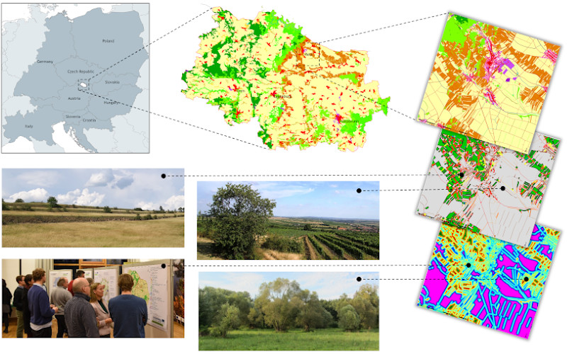
Based on the example of the Austrian case study area, the aim of this paper is to present an easy to use approach, as implemented in ML, for producing a highly-detailed regional GI database to overcome the difficulty of realising comprehensive biotope mapping surveys as well as the rather coarse resolution of CORINE Land Cover (CLC). By compiling regional cadastral and agricultural information, highly detailed data on the water network as well as Pan-European High Resolution Layers (HRL), this detailed representation of the regional GI network allows to enhance the regional applicability and acceptance of GI initiatives and provides a crucial foundation for assessing GI connectivity and functionality to develop evidence-based strategies and action plans through stakeholder involvement to direct future actions and investment in GI.
References
Benedict, M. A., & McMahon, E. T. 2002. Green infrastructure: smart conservation for the 21st century. Renewable resources journal, 20(3), 12-17.
Benedict, M. A., & McMahon, E. T. 2012. Green infrastructure: linking landscapes and communities. Island press. doi:10.1007/s10980-006-9045-7 DOI: https://doi.org/10.1007/s10980-006-9045-7
Bergès, L., Avon, C., Bezombes, L., Clauzel, C., Duflot, R., Foltête, J. C., Gaucherand, S., Girardet, X. & Spiegelberger, T. 2020. Environmental mitigation hierarchy and biodiversity offsets revisited through habitat connectivity modelling. Journal of Environmental Management, 256, 109950. doi:10.1016/j.jenvman.2019.109950 DOI: https://doi.org/10.1016/j.jenvman.2019.109950
BfN - German Federal Agency for Nature Conservation . 2017. Federal Green Infrastructure Concept. https://www.bfn.de/fileadmin/BfN/planung/bkgi/Dokumente/BKGI_Broschuere_englisch.pdf [Accessed 19 February 2020].
BMLFUW - Austrian Federal Ministry of Agriculture, Forestry, Environment and Water Management. 2014. Biodiversitätsstrategie Österreich 2020+. https://www.bmlrt.gv.at/dam/jcr:7dd9ff6f-1a39-4f77-8c51-6dceaf6b195f/Biodiversit%C3%A4tsstrategie2020_dt.pdf [Accessed 19 February 2020].
De Groot, R. S. 2006. Function-analysis and valuation as a tool to assess land use conflicts in planning for sustainable, multifunctional landscapes. Landscape and Urban Planning 75:175-186. doi:10.1016/j.landurbplan.2005.02.016 DOI: https://doi.org/10.1016/j.landurbplan.2005.02.016
De Groot, R. S., Alkemade, R., Braat, L., Hein, L., Willemen, L. 2010. Challenges in integrating the concept of ecosystem services and values in landscape planning, management and decision making. Ecological Complexity 7:260-272. doi:10.1016/j.ecocom.2009.10.006 DOI: https://doi.org/10.1016/j.ecocom.2009.10.006
De Groot, R. S., Wilson, M. A., Boumans, R. M. J. 2002. A typology for the classification, description and valuation of ecosystem functions, goods and services. Ecological Economics 41(3):393-408. doi:10.1016/S0921-8009(02)00089-7 DOI: https://doi.org/10.1016/S0921-8009(02)00089-7
European Union. 2013. Building a green infrastructure for Europe. https://ec.europa.eu/environment/nature/ecosystems/docs/green_infrastructure_broc.pdf [Accessed 19 February 2020].
Gurrutxaga, M., Lozano, P. J., & del Barrio, G. 2010. GIS-based approach for incorporating the connectivity of ecological networks into regional planning. Journal for Nature Conservation, 18(4), 318-326. doi:10.1016/j.jnc.2010.01.005 DOI: https://doi.org/10.1016/j.jnc.2010.01.005
Huang, H., Zhang, M., Yu, K., Gao, Y., & Liu, J. 2020. Construction of complex network of green infrastructure in smart city under spatial differentiation of landscape. Computer Communications, 154, 380-389. doi:10.1016/j.comcom.2020.02.042 DOI: https://doi.org/10.1016/j.comcom.2020.02.042
Honeck, E., Moilanen, A., Guinaudeau, B., Wyler, N., Schlaepfer, M. A., Martin, P., Sanguet, A., Urbina, L., Von Arx, B., Massy, J., Fischer, C., Lehmann, A. 2020. Implementing Green Infrastructure for the Spatial Planning of Peri-Urban Areas in Geneva, Switzerland. Sustainability, 12(4), 1387. doi:10.3390/su12041387 DOI: https://doi.org/10.3390/su12041387
Moilanen, A., & Hanski, I. 1998. Metapopulation dynamics: effects of habitat quality and landscape structure. Ecology, 79(7), 2503-2515. doi:10.1890/0012-9658(1998)079[2503:MDEOHQ]2.0.CO;2 DOI: https://doi.org/10.1890/0012-9658(1998)079[2503:MDEOHQ]2.0.CO;2
Natural England. 2009. Natural England's Green Infrastructure Guidance - NE176. http://publications.naturalengland.org.uk/file/94026 [Accessed 19 February 2020].
Office of the Federal Government of Lower Austria. 2015. Naturschutzkonzept Niederösterreich. http://www.noe.gv.at/noe/Naturschutz/Naturschutzkonzept_Februar_2015.pdf [Accessed 19 February 2020].
Ostapowicz, K., Vogt, P., Riitters, K. H., Kozak, J., & Estreguil, C. 2008. Impact of scale on morphological spatial pattern of forest. Landscape ecology, 23(9), 1107-1117. doi:10.1007/s10980-008-9271-2 DOI: https://doi.org/10.1007/s10980-008-9271-2
Phillips, B. B., Bullock, J. M., Osborne, J. L., & Gaston, K. J. 2020. Ecosystem service provision by road verges. Journal of Applied Ecology, 57(3), 488-501. doi:10.1111/1365-2664.13556 DOI: https://doi.org/10.1111/1365-2664.13556
Ricketts, T. H. 2001. The matrix matters: effective isolation in fragmented landscapes. The American Naturalist, 158(1), 87-99. doi:10.1086/320863 DOI: https://doi.org/10.1086/320863
Soille, P. and Vogt, P. 2009. Morphological segmentation of binary patterns. Pattern recognition letters, 30(4), 456-459. doi:10.1016/j.patrec.2008.10.015 DOI: https://doi.org/10.1016/j.patrec.2008.10.015
Tóth, A. 2016. Greenways as linear components of green infrastructure in rural agricultural landscapes of South-Western Slovakia. In Proceedings of the Fábos Conference on Landscape and Greenway Planning (Vol. 5, No. 1, p. 10).
Vallés-Planells, M., Galiana, F., and Van Eetvelde, V. 2014. A classification of landscape services to support local landscape planning. Ecology and Society 19(1): 44. doi:10.5751/ES-06251-190144 DOI: https://doi.org/10.5751/ES-06251-190144
Vihervaara, P., Kumpula, T., Tanskanen, A., Burkhard, B. 2010. Ecosystem services – a tool for sustainable management of human-environment systems. Case study Finnish Forest Lapland. Ecological Complexity, 7(3), 410-420. doi:10.1016/j.ecocom.2009.12.002 DOI: https://doi.org/10.1016/j.ecocom.2009.12.002
Vihervaara, P., Kumpula, T., Ruokolainen, A., Tanskanen, A., & Burkhard, B. 2012. The use of detailed biotope data for linking biodiversity with ecosystem services in Finland. International Journal of Biodiversity Science, Ecosystem Services & Management, 8(1-2), 169-185. doi:10.1080/21513732.2012.686120 DOI: https://doi.org/10.1080/21513732.2012.686120
Vogt, P., Riitters, K. H., Iwanowski, M., Estreguil, C., Kozak, J., & Soille, P. 2007. Mapping landscape corridors. Ecological Indicators, 7(2), 481-488. doi:10.1016/j.ecolind.2006.11.001 DOI: https://doi.org/10.1016/j.ecolind.2006.11.001
Vogt, P., & Riitters, K. H. 2017. GuidosToolbox: universal digital image object analysis. European Journal of Remote Sensing, 50(1), 352-361. doi:10.1080/22797254.2017.1330650 DOI: https://doi.org/10.1080/22797254.2017.1330650
Wickham, J. D., Riitters, K. H., Wade, T. G., Vogt, P. 2010. A national assessment of green infrastructure and change for the conterminous United States using morphological image processing. Landscape and Urban Planning, 94(3-4), 186-195. doi:10.1016/j.landurbplan.2009.10.003 DOI: https://doi.org/10.1016/j.landurbplan.2009.10.003
Downloads
Published
How to Cite
Issue
Section
Categories
License
Copyright (c) 2021 Florian Danzinger, Stefan Fuchs, Thomas Wrbka

This work is licensed under a Creative Commons Attribution 4.0 International License.